
Skip to content
NOWCAST WLKY News at Noon
Watch on Demand
Advertisement

Severe weather preparedness week in KY: Statewide tornado drill planned

With impact weather forecast for much of the week these weather safety reminders are coming at a perfect time.

Severe weather preparedness week in KY: Statewide tornado drill planned

With impact weather forecast for much of the week these weather safety reminders are coming at a perfect time.

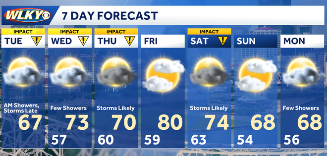
CHIEF METEOROLOGIST JAY CARDOSI. OKAY, AFTER THE RAINFALL OF THE MORNING, SOME NICE WEATHER HAS RETURNED. AND WHAT A CHANGE, RIGHT? THIS MORNING WE’RE AROUND 3940 DEGREES WITH THE RAIN COMING DOWN THIS AFTERNOON. A LITTLE BIT OF SUNSHINE ALL THE WAY UP TO 67 FOR THAT OFFICIAL HIGH GOING FORWARD. HERE THE WEATHER HEADLINES LESS THAN IT’S GOING TO STAY UNSETTLED. I KNOW WE’RE DRY NOW AND THIS IS WHAT WE’RE GOING TO BE DEALING WITH THE NEXT TWO, THREE, FOUR DAYS, MULTIPLE ROUNDS OF SHOWERS AND STORMS. IT’S NOT GOING TO RAIN THE ENTIRE TIME, BUT CERTAINLY KEEP THE UMBRELLAS HANDY. ONE THING’S FOR SURE SPRING LIKE TEMPERATURES. THEY’RE GOING TO CONTINUE FOR QUITE SOME TIME. MATTER OF FACT, BELIEVE IT OR NOT, WE COULD BE VERY CLOSE TO 80 HERE FRIDAY AFTERNOON. ALL RIGHT. THE RADAR SCAN CLEAR AROUND LOUISVILLE, SURROUNDING REGIONS. MUCH OF THE VIEWING AREA VOID OF ANY RAIN. IT’S NOT TOO FAR AWAY. OFF TO THE NORTH. AND ALSO THE NORTHWEST. MATTER OF FACT, A COUPLE OF THUNDERSTORMS ARE MIXING IN IMMEDIATELY WEST OF INDY, OUT THROUGH CENTRAL PORTIONS OF ILLINOIS. NOW FOR THE EVENING HOURS. A LOT OF THIS WILL STAY OFF TO THE NORTH OF US, BUT SOME OF THAT ENERGY MAY TRY TO ARRIVE LATE TONIGHT AFTER MIDNIGHT. AND THAT’S WHY WE’VE INTRODUCED SCATTERED SHOWER AND THUNDERSTORM CHANCES, ESPECIALLY THE NORTHERN ONE HALF OF THE VIEWING AREA. THOSE TEMPERATURES THIS EVENING WILL BE BEAUTIFUL, HOVERING IN THE 60S. AND AGAIN, ONCE THOSE SCATTERED SHOWER AND THUNDERSTORM CHANCES MOVE IN LATE, WE’LL SETTLE BACK INTO THE MID AND UPPER 50S. RIGHT NOW IT’S PRETTY OUT THERE, ISN’T IT? PARTLY SUNNY, 67 DEGREES SOUTH WIND IN HERE AT 14MPH. OTHER TEMPERATURES UPPER 50S. CLOSE TO 60. OUR NORTHERN COMMUNITIES. WE HAVE 61 IN CARROLLTON. EVERYBODY ELSE PRETTY MUCH 65 TO 70. THE WARM SPOT HUNTINGBURG THERE IN DUBOIS COUNTY COMING IN WITH AN EVEN 70. WATCH THE FUTURECAST. HERE WE ARE, 7:00 THIS EVENING. WE’RE JUST FINE AS WE MOVE AFTER MIDNIGHT. OKAY. SOME SCATTERED SHOWERS WILL TRY TO FORM OFF TO THE WEST AND ALSO THE NORTHWEST. EVEN A COUPLE OF THUNDERSTORMS MAY TRY TO MIX IN VERY LATE TONIGHT AND FOR SEVERAL HOURS THEN, JUST LIKE TODAY, I THINK BY TOMORROW, MIDDAY THROUGH THE AFTERNOON, THE GREATER RAIN CHANCES WILL SHIFT BACK OFF TO THE NORTH AND ALSO THE NORTHWEST, AND THAT WILL ALLOW TEMPERATURES TO REBOUND AGAIN. 60S NORTH LOW AND MIDDLE 70S TOMORROW AFTERNOON FROM ABOUT 64 AND POINTS OFF TOWARDS THE SOUTH. NOW THE IMPACT WEATHER. AS I MENTIONED IT’S GOING TO CONTINUE TO COME AT US IN WAVES. THAT’S BECAUSE THIS FRONT IS GOING TO OSCILLATE BACK AND FORTH ACROSS THE OHIO VALLEY. REALLY, THE EASTERN ONE HALF OF THE LOWER 48. THE NEXT 2 TO 3 DAYS, EVERY TIME IT NEARS, WE’LL HAVE THOSE CHANCES FOR SHOWERS AND STORMS. AS FAR AS THE SEVERE THREAT IS CONCERNED TOMORROW, SOUTHERN ILLINOIS AND POINTS OFF TO THE SOUTHWEST GOING FORWARD FOR THURSDAY AND FRIDAY, SEVERE CHANCES THE BETTER. SEVERE CHANCES AGAIN LOOK TO STAY WELL WEST AND SOUTHWEST OF OUR REGION. IT’S NOT TO SAY WE’RE NOT GOING TO GET RAIN. WE COULD GET SEVERAL INCHES OF RAIN FROM TONIGHT RIGHT THROUGH SATURDAY NIGHT TO THE TUNE OF 2 TO 4IN, AND THE ABSOLUTE HEAVIEST AXIS. THAT’S WHERE A FLOOD WATCH HAS BEEN ISSUED. NORTH OF THE OHIO RIVER. SO IT DOES LOOK ACTIVE. AND WE’LL KEEP YOU POSTED AS WE MOVE THROUGH THE REST OF THE WEEK. MAINLY CLOUDY, MILD THIS EVENING. TEMPERATURES IN THE 60S, THOSE RAIN CHANCES RETURNING, BUT NOT UNTIL AFTER MIDNIGHT. DETAILED FORECAST TOMORROW. IMPACT WEATHER THROUGH THE MORNING WITH SCATTERED SHOWERS AND A FEW STORMS. DRIER IN THE AFTERNOON. AT 73, WE’RE 70 ON THURSDAY. MORE SCATTERED SHOWERS AND STORMS. THERE’S YOUR FRIDAY FORECAST. LOOKS GREAT. SOME SUN AND 80. AND THEN WE’LL GET ANOTHER RAIN CHANCE IN HERE SATURDAY BEFORE THINGS QUIET DOWN. BUT IT STAYS NICE AND WARM SUND
WLKY logo
Updated: 6:41 PM EST Mar 3, 2026
Editorial Standards
Advertisement
Severe weather preparedness week in KY: Statewide tornado drill planned

With impact weather forecast for much of the week these weather safety reminders are coming at a perfect time.

WLKY logo
Updated: 6:41 PM EST Mar 3, 2026
Editorial Standards
Severe Weather Awareness week is your reminder that you need to be "Weather Ready" for all types of hazards, such as tornadoes, severe thunderstorms, large hail, lightning, heavy rain, flooding, and high winds.With impact weather forecast for much of the week these reminders are coming at a perfect time. As part of Severe Weather Awareness Week in Kentucky, the National Weather Service will conduct a Statewide Tornado Drill on Wednesday, March 4 at 10:07 a.m. EST.When weather warnings are issued it's important to have multiple ways to receive them, especially at night or when the power goes out.You may also hear sirens when severe weather is coming, but outdoor sirens should never be your only source of weather alerts.Warning sirens are for outdoor warning purposes, and are not meant to be heard indoors or to wake you up at night!That's why it's important to have other ways to get warnings.Weather radios are a valued resource when the power goes out and phone batteries are dead.NOAA Weather Radio uses a nationwide network of radio stations broadcasting continuous weather information directly from the nearest National Weather Service office.NOAA Weather Radio broadcasts official National Weather Service warnings, watches, forecasts and other hazard information 24 hours a day, 7 days a week.Weather radios can be found at local hardware stores and online.

Severe Weather Awareness week is your reminder that you need to be "Weather Ready" for all types of hazards, such as tornadoes, severe thunderstorms, large hail, lightning, heavy rain, flooding, and high winds.

With impact weather forecast for much of the week these reminders are coming at a perfect time.
Advertisement
impact weather
Hearst Owned
Multiple days of impact weather

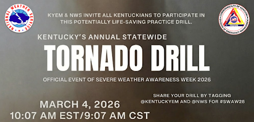
As part of Severe Weather Awareness Week in Kentucky, the National Weather Service will conduct a Statewide Tornado Drill on Wednesday, March 4 at 10:07 a.m. EST.
wlky weather
Hearst Owned
State Wide Tornado Drill Wednesday

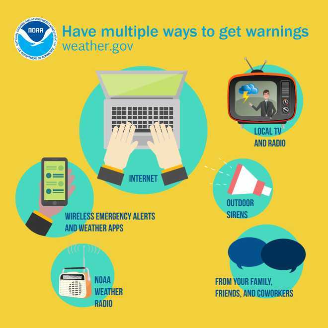
When weather warnings are issued it's important to have multiple ways to receive them, especially at night or when the power goes out.
wlky weather
Hearst OwnedNational Weather Service
Have multiple ways to get warnings

You may also hear sirens when severe weather is coming, but outdoor sirens should never be your only source of weather alerts.

Warning sirens are for outdoor warning purposes, and are not meant to be heard indoors or to wake you up at night!

That's why it's important to have other ways to get warnings.

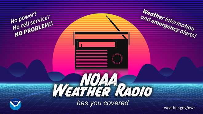
Weather radios are a valued resource when the power goes out and phone batteries are dead.
wlky weather
Hearst OwnedNational Weather Service
Weather radios are a great back up

NOAA Weather Radio uses a nationwide network of radio stations broadcasting continuous weather information directly from the nearest National Weather Service office.

NOAA Weather Radio broadcasts official National Weather Service warnings, watches, forecasts and other hazard information 24 hours a day, 7 days a week.

Weather radios can be found at local hardware stores and online.

Weather Information

FEELS LIKE
RADAR TRAFFIC
Sponsored by
X
Make WLKY a preferred source on Google