Skip to content
NOWCAST WLKY News at Noon
Watch on Demand
Advertisement

Weekly weather planner: Heating up and multiple chances for storms

A hot start to the week with a few chances for impact weather.

Weekly weather planner: Heating up and multiple chances for storms

A hot start to the week with a few chances for impact weather.

YOU’RE WATCHING WLKY NEWS. OUR MONDAY IS STARTING OUT WARM. WE’RE GOING TO SEE TEMPERATURES ON EITHER SIDE OF 70 DEGREES. THE CLOSER THAT YOU LIVE INTO THE HEART OF THE CITY, YOU’RE GOING TO HOLD IN THOSE 70S THE FURTHER FOR THE SUBURBS AND AWAY FROM TOWN WILL START FALLING BACK INTO THOSE 60S. BUT IT’S GOING TO BE A QUICK WARM UP WITH JUST A FEW CLOUDS THROUGH MIDDAY. WE’RE GOING TO BE BREEZY AS WELL. HIGHS GO WARMER. TEMPERATURES, I SHOULD SAY, GO INTO THE MID 80S WITH HIGHS GOING IN THE LOW 90S. FIRST TIME THIS YEAR IN THE 90S. AT 91 IT’S GOING TO BE A SUMMERLIKE DAY NO DOUBT. WATCH FOR A FEW ISOLATED STORMS LATE DAY AND INTO THE EVENING, ESPECIALLY NORTH AND WEST OF TOWN INTO SOUTHERN INDIANA. IT’S PART OF A SYSTEM I’M WATCHING THROUGH NORTHERN PORTIONS OF MISSOURI. THAT LINE OF STORMS AS IT TRIES THE DAY, COULD PUT DOWN SOME DOWNPOURS AND SOME THUNDERSTORM ACTIVITY IN OUR NORTH AND WESTERN COMMUNITIES. IF YOU’RE WATCHING FROM NEAR PATOKA, LAKE, PAOLI, SALEM, SCOTTSBURG, SEYMOUR. NORTH VERNON, MAYBE MADISON, THOSE ARE GOING TO BE THE LOCATIONS THAT YOU’LL HAVE TO BE ON GUARD FOR A FEW OF THESE SHOWERS AND STORMS AS WE HEAD INTO THE EVENING. ONCE WE SET THE SUN AND START TO COOL THE TEMPERATURES, THESE SHOULD WIND DOWN OVERNIGHT. WE’RE QUIET TOMORROW MORNING, BUT WE START TO GET A FRONTAL SYSTEM CLOSER TO US LATER IN THE DAY, TOMORROW AND INTO TOMORROW NIGHT. SO WE BEGIN TO SEE ANOTHER STORMS. THIS TIME A FEW OF THEM ARE GOING TO MAKE IT A LITTLE FARTHER OFF TOWARDS THE SOUTH AND EAST, AND THEY’LL EVEN BE SOME RENEWED ACTIVITY TO THE WEST FOR TUESDAY NIGHT. SO WE START TO GET INTO A STORM OUTLOOK THAT GETS INTO A LEVEL TWO OUT OF FIVE FOR A CHANCE OF STRONG TO MAYBE EVEN SEVERE STORMS. BIGGEST CONCERN WOULD BE WIND GUSTS, PERHAPS UP TO 60MPH. AND SOME HAILSTONES. THOSE THREATS ARE LOWER. THE FARTHER SOUTH AND EAST YOU GO ACROSS THE REGION. BUT WE’LL KEEP CLOSE EYES ON IT. IT IS IMPACT WEATHER TOMORROW. STILL A VERY WARM BUT UNSETTLED DAY AT 88 DEGREES. FRONT MOVES THROUGH. WE LINGER A FEW SHOWERS WEDNESDAY MORNING BUT TREND DRIER AND COOLER IN THE AFTERNOON WITH HIGHS IN THE MID 70S. PARTLY SUNNY, 70 FOR THURSDAY. THAT LOOKS TO BE ONE OF THE PICKS OF THE SEVEN DAY. BECAUSE SHOWER AND STORM CHANCES COME BACK OUR WAY. LIKELY FRIDAY SCATTERED SATURDAY. AND WHILE SUNDAY I THINK HOLDS MO
WLKY logo
Updated: 9:31 AM EDT May 18, 2026
Editorial Standards
Advertisement
Weekly weather planner: Heating up and multiple chances for storms

A hot start to the week with a few chances for impact weather.

WLKY logo
Updated: 9:31 AM EDT May 18, 2026
Editorial Standards
It'll be a (very) hot start to the week and we have a few chances for impact weather.The summer heat continues on Monday with highs climbing into the upper 80s to lower 90s. If we can reach 90, it will be our first time for 2026.Monday late afternoon into the evening, there is a chance for a few storms to develop over southern Indiana.Tuesday is an impact weather day, as our next strong cold front sweeps towards the Ohio Valley.This front will produce a couple rounds of scattered showers and storms Tuesday afternoon and evening.The main threat for storms Tuesday will be damaging wind gusts up to 60 mph, large hail, and intense downpours with lots of lightning. A brief spin-up tornado is also possible.The front should push south of the region by Wednesday morning, but a few showers could linger into the first half of Wednesday, especially down closer to the parkways.The remainder of Wednesday will feature some sunshine in the afternoon and temps just a touch below normal in the mid-70s. Thursday has a mix of clouds and sunshine with highs in the low and mid-70s. Temperatures are closer to normal by Friday but we're also watching for more impact weather as another storm system moves into the Ohio Valley. Rain and storms will linger into the first half of the weekend on a more scattered basis with temperatures climbing towards 80. The heat continues to build on Sunday with a few pop up storms and highs in the low 80s.

It'll be a (very) hot start to the week and we have a few chances for impact weather.

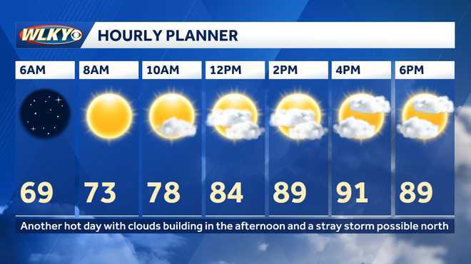
The summer heat continues on Monday with highs climbing into the upper 80s to lower 90s.

Advertisement

If we can reach 90, it will be our first time for 2026.
weekly weather planner
Hearst Owned
Heating up Monday!

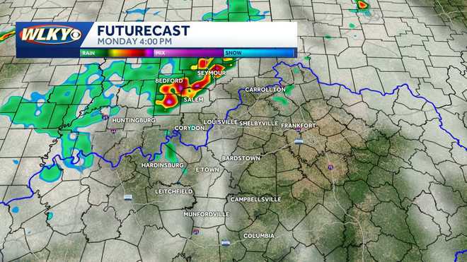
Monday late afternoon into the evening, there is a chance for a few storms to develop over southern Indiana.
weekly weather planner
Hearst Owned
Few Storms late Monday afternoon

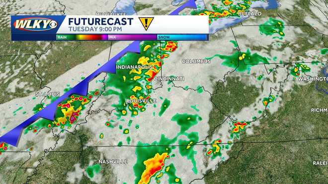
Tuesday is an impact weather day, as our next strong cold front sweeps towards the Ohio Valley.

This front will produce a couple rounds of scattered showers and storms Tuesday afternoon and evening.
weekly weather planner
Hearst Owned
Tuesday storms

The main threat for storms Tuesday will be damaging wind gusts up to 60 mph, large hail, and intense downpours with lots of lightning. A brief spin-up tornado is also possible.

The front should push south of the region by Wednesday morning, but a few showers could linger into the first half of Wednesday, especially down closer to the parkways.

The remainder of Wednesday will feature some sunshine in the afternoon and temps just a touch below normal in the mid-70s.

Thursday has a mix of clouds and sunshine with highs in the low and mid-70s.

Temperatures are closer to normal by Friday but we're also watching for more impact weather as another storm system moves into the Ohio Valley.

Rain and storms will linger into the first half of the weekend on a more scattered basis with temperatures climbing towards 80.

The heat continues to build on Sunday with a few pop up storms and highs in the low 80s.
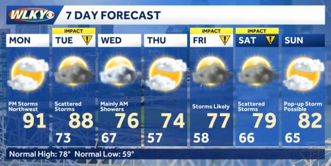
weekly weather planner
Hearst Owned
Unsettled week ahead

Weather Information

FEELS LIKE
RADAR TRAFFIC
Sponsored by
X
Make WLKY a preferred source on Google