Memorial Day weekend weather planner: Drying up for Memorial Day
After a rainy Sunday it does look like we will close out the holiday weekend with drier weather and some sunshine Monday.
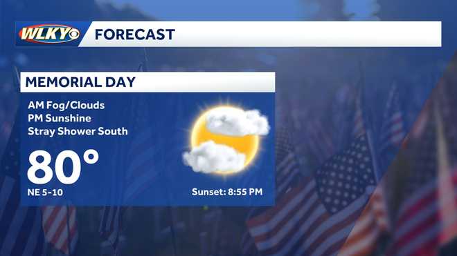
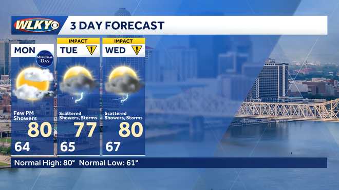
METEOROLOGIST ERIC ZERNICH. IT WAS A WET START TO OUR SUNDAY WITH LIGHT RAIN TO GET THE DAY STARTED. THEN WE HAD SOME HEAVIER SHOWERS MOVE THROUGH AROUND 3:00, ESPECIALLY HERE IN DOWNTOWN LOUISVILLE AND MUCH OF THE METRO. BUT WE DID START TO TREND DRIER AS WE PUSHED INTO THE EVENING. WE JUST HAVE A FEW STRAY LIGHT SHOWERS OUT THERE. THOSE ARE GOING TO BE ENDING AS WE HEAD THROUGH THE OVERNIGHT HOURS. WE’LL LOOK AT MAINLY DRY AND SUNNY CONDITIONS FOR MEMORIAL DAY, SO I DO THINK WE’LL BE ABLE TO SALVAGE ONE DAY OF THIS HOLIDAY WEEKEND AND ENJOY SOME OF THOSE OUTDOOR ACTIVITIES BEFORE THEN. SCATTERED SHOWERS RETURN AS WE HEAD INTO TUESDAY AND WEDNESDAY, WE’LL HAVE MORE ROUNDS OF IMPACT WEATHER MOVING BACK IN. SO HERE’S THE LAST THREE HOURS ON THE RADAR. AND YOU CAN SEE IT HAS BEEN FAIRLY QUIET ACROSS MUCH OF THE AREA. WE’VE HAD JUST A FEW LIGHT SHOWERS IN SOUTHERN INDIANA, BUT THOSE ARE QUICKLY FALLING APART. AND IT LOOKS LIKE WE ARE PRETTY MUCH DONE AS WE ZOOM IN ACROSS CLARK COUNTY. YOU CAN SEE JUST SOME VERY LIGHT RETURN SHOWING UP TOWARDS THE HENRYVILLE AREA. SO MAYBE JUST A FEW SPRINKLES IS ALL THAT CAN MAKE IT INTO CHARLESTOWN AND SELLERSBURG, BUT I WOULD EXPECT THIS TO FALL APART AND PRETTY MUCH BE DONE BY THE TIME WE HEAD TOWARDS MIDNIGHT. SO WHAT WE HAVE IS A COLD FRONT THAT IS FINALLY MAKING ITS WAY THROUGH AND TAKING THE RAIN AND PUSHING IT OFF TO THE EAST. YOU CAN SEE WE GOT THE DRIER SKIES BEHIND IT, AND THAT SHOULD LEAD TO THOSE QUIETER CONDITIONS FOR MEMORIAL DAY. THIS FRONT IS THEN GOING TO PIVOT BACK TO THE SOUTH BEFORE LIFTING TO THE NORTH, LEADING TO THOSE RAIN CHANCES TUESDAY AND INTO WEDNESDAY. SO LOOKING AT TONIGHT, YOU CAN SEE WE’LL HANG ON TO SOME CLOUDS AND I THINK WE’LL GET SOME FOG IN HERE. TOMORROW MORNING. WILL BE PATCHY TO DENSE IN A FEW LOCATIONS, ESPECIALLY THOSE VALLEY LOCATIONS AS IT HAS BEEN VERY WET OF LATE. SO IT’S GOING TO SET UP THE PERFECT CONDITIONS WITH LIGHT WINDS FOR FOG TO GET OUR MONDAY STARTED. BUT BY THE AFTERNOON YOU CAN SEE THE CLOUDS BREAK UP. WE’LL GET SOME NICE SUNSHINE IN HERE. AND I DO THINK IT TURNS INTO A GOOD LOOKING MEMORIAL DAY WITH TEMPERATURES NEAR 80 DEGREES FOR AN AFTERNOON HIGH. SO WITH THAT, SUNSHINE SHOULD FEEL VERY COMFORTABLE FOR THOSE OUTDOOR ACTIVITIES. HEADING TO THE POOL TOMORROW. SO JUST KIND OF KEEP THAT IN MIND, BUT HAVE THE UMBRELLA READY AS WE HEAD BACK TO WORK ON TUESDAY. WE’LL START DRY. SO I DO THINK THE TUESDAY MORNING COMMUTE IS GOOD. FOR THE MOST PART. YOU CAN SEE RAIN TO THE SOUTH. THAT’S GOING TO SLOWLY LIFT UP AS THAT FRONT WORKS BACK INTO SOME SCATTERED SHOWERS MOVING IN BY EARLY AFTERNOON. CONTINUING THROUGH THE AFTERNOON, IT’S NOT GOING TO BE WIDESPREAD, BUT DEFINITELY A DECENT CHANCE FOR AT LEAST SOME HIT OR MISS SHOWERS. ON TUESDAY, THINGS BEGIN TO QUIET DOWN TUESDAY EVENING BEFORE ANOTHER ROUND WEDNESDAY AFTERNOON, SO GET YOU OUTSIDE HERE FOR THIS SUNDAY NIGHT AS WE KIND OF MOVE DEEPER INTO THE HOLIDAY WEEKEND. GOT SOME CLOUDS, BUT WE’RE DRY. 69 DEGREES IS WHAT WE’RE CURRENTLY SITTING AT. WE’LL DROP INTO THE MID 60S AGAIN. CHANCE FOR SOME PATCHY FOG AND A LOT OF CLOUD COVER THE START OF MEMORIAL DAY, BUT IT DOES LOOK TO BE A MAINLY DRY AFTERNOON WITH THAT SUNSHINE BREAKING THROUGH, WARMING TEMPERATURES UPPER 70S TO NEAR 80 DEGREES FOR THAT AFTERNOON. HIGH. AND THEN THE IMPACT WEATHER, AS I MENTIONED, RETURNS TUESDAY AND WEDNESDAY WITH SCATTERED SHOWERS AND A FEW THUNDERSTORMS BOTH DAYS. TEMPERATURES UPPER 70S TO NEAR 80 DEGREES. WE’LL HANG ON TO JUST A FEW SHOWERS THURSDAY AND FRIDAY, BUT DEFINITELY STARTING THE TREND DRIER WITH TEMPERATURES INTO THE LOW TO MID 80S. AND AS WE LOOK TOWARDS NEXT WEEKEND, NOT LOOKING TOO BAD, RELATIVELY DRY, A MIX OF SUN AND CLOUDS AND TEMPERATURES IN THE MID TO UPPER 70S, SO NO MAJOR WARM UPS. JUST GOING TO BE DEALING WITH A FEW MORE SHOWERS. BUT AT LEAST WE GET THE BREAK TOMORROW FOR MEMORIAL DAY. YEAH. THANK GOODNESS. SO KEEP THE UMBRELLA HANDY JUST IN CASE. DON’T PUT I
Memorial Day weekend weather planner: Drying up for Memorial Day
After a rainy Sunday it does look like we will close out the holiday weekend with drier weather and some sunshine Monday.
![WLKY logo]()
Updated: 11:27 PM EDT May 24, 2026
Editorial Standards ⓘ
Sunday turned into a pretty wet day with light to moderate showers for much of the morning and afternoon.There is a decent chance for patchy to dense fog to start our Monday.LIVE WEATHER RADAR | WEATHER ALERTS The good news is Memorial Day is trending drier with a fair bit of sunshine in the afternoon to warm highs to near 80. As we head back to work after the holiday weekend, more showers and storms will be in the forecast through Thursday. The weather pattern finally looks to trend a bit drier Friday.
LOUISVILLE, Ky. — Sunday turned into a pretty wet day with light to moderate showers for much of the morning and afternoon.
There is a decent chance for patchy to dense fog to start our Monday.
LIVE WEATHER RADAR | WEATHER ALERTS
The good news is Memorial Day is trending drier with a fair bit of sunshine in the afternoon to warm highs to near 80.
Hearst Owned
Memorial Day Forecast
As we head back to work after the holiday weekend, more showers and storms will be in the forecast through Thursday. The weather pattern finally looks to trend a bit drier Friday.
Hearst Owned
Showers and storms return Tuesday and Wednesday