Flood watch canceled for several counties throughout the WLKY viewing area
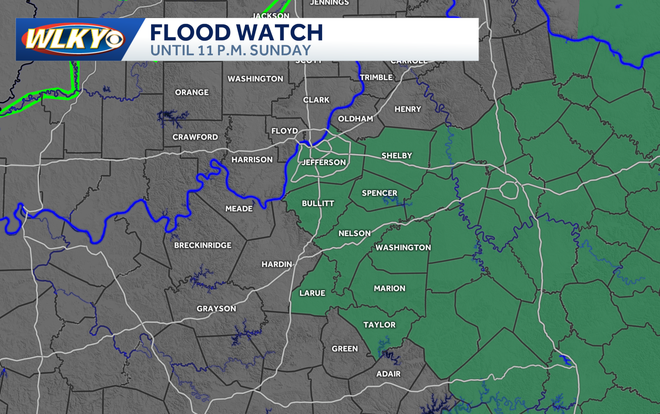
Officials have canceled a flood watch that was in effect for several counties across the WLKY viewing area.
METEOROLOGIST MO ROSE. WELL GOOD SUNDAY MORNING TO YOU. IT IS AN IMPACT WEATHER DAY. WE’VE HEARD THIS A WHOLE BUNCH. WE’RE GOING TO BE WATCHING FOR SOME SHOWERS EARLY AND THEN A FEW STORMS LATER ON TODAY. NOW MOST DAYS, AS WE LOOK AHEAD TO THE SEVEN DAY FORECAST, THEY WILL NOT BE WASHOUTS. BUT WHEN WE DO HAVE IMPACT WEATHER WITH SOME OF THOSE SHOWERS AND STORMS, WITH THE RAIN THAT WE HAVE HAD, WE COULD SEE SOME LOCALIZED FLOODING. AND WE’LL ALSO BE WATCHING FOR THOSE POCKETS OF HEAVY RAIN. JUST REMEMBER, IF YOU ARE GOING TO BE DRIVING OUT IN AN AREA WITH POOR DRAINAGE, MAKE SURE YOU’RE NOT DRIVING THROUGH ANY ROADS THAT ARE FLOODED. YOU WANT TO TURN AROUND. ALL RIGHT, 66 RIGHT NOW, NO RAIN IN THE METRO. WE’RE ACTUALLY EXPERIENCING SOME PATCHY FOG. TEMPERATURES ARE COOLER TO THE NORTH. THEY’RE IN THE LOW 60S IN NORTH VERNON AND SEYMOUR, WARMER TO OUR SOUTH OF THE PARKWAYS THERE IN THE UPPER 60S. PRETTY MUCH FOR EVERYONE THERE. NOW WE ARE GOING TO BE LOOKING OUT FOR MORE SHOWERS AS WE GET THROUGH THE MORNING. TODAY’S HIGH LIKELY GETTING CLOSE TO 80. THE MORE WE WARM UP, THE BETTER CHANCE WE’LL BE ABLE TO FUEL SOME THUNDERSTORMS. BUT SHOWERS WILL LIKELY BE EARLY THANKS TO A VERY WEAK COLD FRONT THAT’S DRAPED OVER OUR REGION. NOW, WALKING YOU THROUGH OUR FUTURE RADAR, WE’RE GOING TO START LOOKING FOR THOSE SHOWERS. WE DO HAVE A FEW OF THEM DOWN IN SOUTH OF THE PARKWAYS. NO STORMS RIGHT NOW. BUT AGAIN, AS THE TEMPERATURES WARM, WE ARE GOING TO BE WATCHING FOR A COUPLE OF THOSE HEAVY DOWNPOURS. THEY COULD END UP WITH SOME RUMBLES OF THUNDER. SO WE’LL WATCH THAT CLOSELY, ESPECIALLY INTO THE AFTERNOON. NOT EVERYONE IS GOING TO GET IN ON THE RAIN TODAY, BUT IF YOU DO GET A SHOWER, IT MAY BE HEAVY. AND AGAIN, THERE MIGHT BE A GUSTY THUNDERSTORM WITH IT. THE LATER WE GET THOUGH, THINGS START TO CALM DOWN. THE SUN SETS. WE LOSE THAT INSTABILITY AND THEN THE WEATHER STARTS TO QUIET DOWN. SO FOR TOMORROW MORNING, IT’S ACTUALLY GOING TO BE A VERY CALM START. WE JUST HAVE SOME CLOUD COVER AND THEN AS WE GET INTO THE AFTERNOON, A MAINLY CLOUDY SKY WILL HOLD ON TO SOME ISOLATED SHOWER CHANCES. BUT I THINK WE CAN GET AWAY WITHOUT SOME STORMS FOR TOMORROW. SO THIS IS QUITE A DIFFERENT FORECAST THAN WHAT WE WERE LOOKING AT A COUPLE OF DAYS AGO. THE WEATHER IS ALWAYS CHANGING, BUT THIS CHANGE IS FOR THE BETTER. SO OUTDOOR PLANS KEEP THEM FOR YOUR MEMORIAL DAY EVEN TODAY. JUST KNOW THAT YOU HAVE TO RUN INSIDE. IF YOU HEAR A RUMBLE OF THUNDER. BY TUESDAY, THOUGH, THE SHOWER AND STORM CHANCES RETURN. IMPACT WEATHER BOTH TUESDAY AND WEDNESDAY. JUST A FEW SHOWERS ON THURSDAY AND HAVEN’T SEEN THIS IN A WHILE. A DRY DAY ON FRIDAY. WE’
Flood watch canceled for several counties throughout the WLKY viewing area
Officials have canceled a flood watch that was in effect for several counties across the WLKY viewing area.
![WLKY logo]()
Updated: 6:46 PM EDT May 24, 2026
Editorial Standards ⓘ
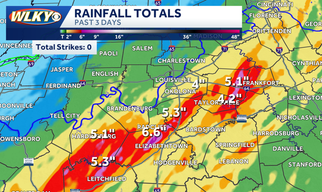
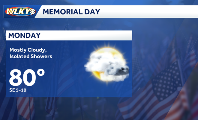
Update: The flood watch has been canceled.The National Weather Service has issued a flood watch for a handful of counties, including the Louisville Metro until 11 p.m. as rounds of showers and storms are forecast to fall through the afternoon and evening over areas that have already seen a large amount of rain. Just in the last few days some areas have seen over 6 inches of rain. The forecast looks drier for Memorial Day with just a few isolated showers however another round of impact weather will return on Tuesday and Wednesday bringing another threat of storms and flooding to the region. For those spending time outdoors this afternoon it's important to be weather aware. If thunder roars, head indoors and remain sheltered for at least 30 minutes after the last clap of thunder. PGlmcmFtZSBzcmM9Imh0dHBzOi8vd3d3LmZhY2Vib29rLmNvbS9wbHVnaW5zL3ZpZGVvLnBocD9oZWlnaHQ9MzE0JmhyZWY9aHR0cHMlM0ElMkYlMkZ3d3cuZmFjZWJvb2suY29tJTJGcmVlbCUyRjIyMzM3OTEwNjA3NTk3MTAlMkYmc2hvd190ZXh0PWZhbHNlJndpZHRoPTU2MCZ0PTAiIHdpZHRoPSI1NjAiIGhlaWdodD0iMzE0IiBzdHlsZT0iYm9yZGVyOm5vbmU7b3ZlcmZsb3c6aGlkZGVuIiBzY3JvbGxpbmc9Im5vIiBmcmFtZWJvcmRlcj0iMCIgYWxsb3dmdWxsc2NyZWVuPSJ0cnVlIiBhbGxvdz0iYXV0b3BsYXk7IGNsaXBib2FyZC13cml0ZTsgZW5jcnlwdGVkLW1lZGlhOyBwaWN0dXJlLWluLXBpY3R1cmU7IHdlYi1zaGFyZSIgYWxsb3dGdWxsU2NyZWVuPSJ0cnVlIj48L2lmcmFtZT4=Don't forget to download the WLKY app on your phone to get warnings sent directly to your mobile device while you're away from the television. PGlmcmFtZSBzcmM9Imh0dHBzOi8vd3d3LmZhY2Vib29rLmNvbS9wbHVnaW5zL3ZpZGVvLnBocD9oZWlnaHQ9MzE0JmhyZWY9aHR0cHMlM0ElMkYlMkZ3d3cuZmFjZWJvb2suY29tJTJGcmVlbCUyRjIwMDU0NjkyNjY3MTQ0NzclMkYmc2hvd190ZXh0PWZhbHNlJndpZHRoPTU2MCZ0PTAiIHdpZHRoPSI1NjAiIGhlaWdodD0iMzE0IiBzdHlsZT0iYm9yZGVyOm5vbmU7b3ZlcmZsb3c6aGlkZGVuIiBzY3JvbGxpbmc9Im5vIiBmcmFtZWJvcmRlcj0iMCIgYWxsb3dmdWxsc2NyZWVuPSJ0cnVlIiBhbGxvdz0iYXV0b3BsYXk7IGNsaXBib2FyZC13cml0ZTsgZW5jcnlwdGVkLW1lZGlhOyBwaWN0dXJlLWluLXBpY3R1cmU7IHdlYi1zaGFyZSIgYWxsb3dGdWxsU2NyZWVuPSJ0cnVlIj48L2lmcmFtZT4=
Update: The flood watch has been canceled.
The National Weather Service has issued a flood watch for a handful of counties, including the Louisville Metro until 11 p.m. as rounds of showers and storms are forecast to fall through the afternoon and evening over areas that have already seen a large amount of rain.
Just in the last few days some areas have seen over 6 inches of rain.
Hearst Owned
Some areas seeing over 6 inches of rain over the last three days.
The forecast looks drier for Memorial Day with just a few isolated showers however another round of impact weather will return on Tuesday and Wednesday bringing another threat of storms and flooding to the region.
Hearst Owned
Mainly Dry Monday
For those spending time outdoors this afternoon it's important to be weather aware.
If thunder roars, head indoors and remain sheltered for at least 30 minutes after the last clap of thunder.
Don't forget to download the WLKY app on your phone to get warnings sent directly to your mobile device while you're away from the television.