Chances for storms, heavy rain return on Tuesday and Wednesday
Watching for rain and a few storms to move in to our southern counties Tuesday morning and eventually overspread the region by the afternoon.
YOU’RE WATCHING WLKY NEWS. AND IT IS AN IMPACT WEATHER DAY THIS TUESDAY. SHOWERS ARE LIKELY, IN FACT, THEIR GUARANTEE IN OUR SKIES TODAY. A FEW STORMS WILL BE POSSIBLE, ESPECIALLY INTO THE AFTERNOON AND A FEW OF THOSE STORMS AS WELL WILL HAVE A CHANCE TO GET ON THE STRONG SIDE, MAINLY SOUTH AND SOUTHEAST OF LOUISVILLE A BIT LATER ON TODAY, WE’LL ALSO WATCH FOR SOME HEAVY DOWNPOURS BECAUSE WE’VE HAD SO MUCH RAIN LATELY. THE GROUND IS NOW SATURATED, SO ANY TROPICAL STYLE DOWNPOURS THAT ACCOMPANY, ESPECIALLY ANY OF THE THUNDERSTORMS, COULD LEAD TO SOME ISOLATED REPORTS OF SOME FLASH FLOODING. SO WE KEEP EYES ON ALL OF THAT FOR YOU. STEMMING FROM AN AREA OF LOW PRESSURE OFF TO THE SOUTH AND WEST THAT’S ALREADY SENDING SOME OF THOSE SHOWERS INTO SOUTHERN AND CENTRAL KENTUCKY. THOSE ARE GOING TO LIFT NORTH THROUGH THE COURSE OF THE MORNING. AND THEN AGAIN, WE’LL TURN OUR ATTENTION TO SOME OF THOSE STORMS LATER IN THE DAY. SO 60 FOR OUR TEMPERATURES TO GET YOU STARTED AS THAT RAIN MOVES IN, SHOWERS LIKELY MIDDAY AT 71 DEGREES. AND WHILE WE DO CATCH A FEW BREAKS, I THINK IN THE RAIN DURING THE AFTERNOON, THAT’S ALSO WHEN WE’LL TURN OUR ATTENTION TO A FEW STORM POSSIBILITIES. WITH HIGHS NEAR 77 TODAY. BUT ACTUALLY LIKE THAT NUMBER TO BE A LITTLE BIT LOWER, THAT WOULD BE GOOD NEWS. WOULDN’T FUEL AS MANY STORMS, BUT WE WATCH IT CLOSELY BECAUSE RAIN IS BUILDING THROUGH THE MORNING FROM SOUTH TO NORTH ACROSS THE REGION. AGAIN, WATCH FOR A FEW HEAVY DOWNPOURS TOO, AS WE GET INTO THE AFTERNOON. WE’LL KEEP EYES ON ANY CELLS THAT CAN GET GOING. THOSE WOULD BE THE ISOLATED STORMS THAT COULD GET ON THE STRONG SIDE. A LITTLE LATER ON THIS AFTERNOON. BUT NOTICE HOW THAT ALL FADES AWAY AFTER SUNSET TONIGHT. WE DON’T DEAL WITH A STORM THREAT, BUT A COUPLE OF SHOWERS WILL BE SPOTTY ACROSS THE AREA OVERNIGHT AND INTO TOMORROW MORNING. AND THEN WE’LL KEEP A WIDELY SCATTERED SHOWER CHANCE AND EVEN A FEW STORMS INTO OUR WEDNESDAY NOTICE. IT’S NOT AN ALL DAY WASHOUT. NOT AS MUCH COVERAGE ON FUTURECAST AS WHAT WE HAVE TODAY, BUT STILL SOME DOWNPOURS TO BE DODGED. SO TODAY AND TOMORROW. IMPACT WEATHER DAYS. HIGHS UP TO 80. TOMORROW 84. AS WE DRY OUT ON THURSDAY WE START TO WORK IN A FRONTAL SYSTEM. FRIDAY INTO THE WEEKEND THAT WILL START DIPPING OUR TEMPERATURES BACK INTO THE 70S FOR HIGHS. WE’RE ONLY 72 ON SUNDAY BEFORE WE GET BACK TO THE UPPER 70S BY MONDAY OF NEXT WEEK. AND LOOK AT THOSE LOWS TOO. FRIDAY THROUGH THE WEEKEND INTO EARLY NEXT WEEK WILL BE FREQUENTLY IN THE 50S. THAT’S GOING TO BE COOL FOR THE THAT WE’RE GOING TO GET RID OF SO
Chances for storms, heavy rain return on Tuesday and Wednesday
Watching for rain and a few storms to move in to our southern counties Tuesday morning and eventually overspread the region by the afternoon.
![WLKY logo]()
Updated: 11:57 AM EDT May 26, 2026
Editorial Standards ⓘ
Rain moves into the WLKY region Tuesday morning and eventually overspreads the region by the afternoon. Storms will also be possible in the afternoon.LIVE WEATHER RADAR | WEATHER ALERTS PGlmcmFtZSBzcmM9Imh0dHBzOi8vd3d3LmZhY2Vib29rLmNvbS9wbHVnaW5zL3ZpZGVvLnBocD9oZWlnaHQ9MzE0JmhyZWY9aHR0cHMlM0ElMkYlMkZ3d3cuZmFjZWJvb2suY29tJTJGcmVlbCUyRjEwMzA4NTYxMzkzNzAxOTElMkYmc2hvd190ZXh0PWZhbHNlJndpZHRoPTU2MCZ0PTAiIHdpZHRoPSI1NjAiIGhlaWdodD0iMzE0IiBzdHlsZT0iYm9yZGVyOm5vbmU7b3ZlcmZsb3c6aGlkZGVuIiBzY3JvbGxpbmc9Im5vIiBmcmFtZWJvcmRlcj0iMCIgYWxsb3dmdWxsc2NyZWVuPSJ0cnVlIiBhbGxvdz0iYXV0b3BsYXk7IGNsaXBib2FyZC13cml0ZTsgZW5jcnlwdGVkLW1lZGlhOyBwaWN0dXJlLWluLXBpY3R1cmU7IHdlYi1zaGFyZSIgYWxsb3dGdWxsU2NyZWVuPSJ0cnVlIj48L2lmcmFtZT4=The threat for storms will be highest in our southern counties, where a few storms could become strong. Main concerns will be for isolated damaging wind gusts and even a chance for a spin-up tornado.Bigger impact concerns are from heavy rain and the chance for localized flooding. Forecasted rain totals for Tuesday and Wednesday are under an inch in some places to over 1.5" in other areas however new data coming in suggests that we could see some localized amounts closer to 2-3". While higher rain totals could pose a problem for flood prone areas the locations seeing most of the rain are also the areas who need it the most. Counties along and south of the parkways are under a severe drought. This week's rain should continue to help alleviate those conditions.
LOUISVILLE, Ky. — Rain moves into the WLKY region Tuesday morning and eventually overspreads the region by the afternoon. Storms will also be possible in the afternoon.
LIVE WEATHER RADAR | WEATHER ALERTS
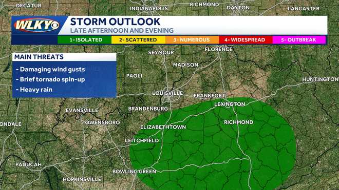
The threat for storms will be highest in our southern counties, where a few storms could become strong. Main concerns will be for isolated damaging wind gusts and even a chance for a spin-up tornado.
Hearst Owned
Tuesday storm outlook
Bigger impact concerns are from heavy rain and the chance for localized flooding.
Hearst Owned
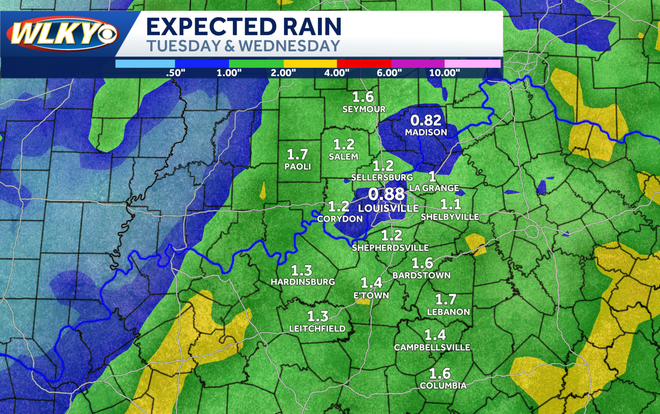
Rain totals from Tuesday and Wednesday
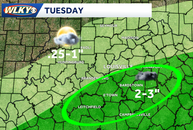
Forecasted rain totals for Tuesday and Wednesday are under an inch in some places to over 1.5" in other areas however new data coming in suggests that we could see some localized amounts closer to 2-3".
Hearst Owned
Some localized areas could see 2-3 inches of rain
While higher rain totals could pose a problem for flood prone areas the locations seeing most of the rain are also the areas who need it the most.
Hearst Owned
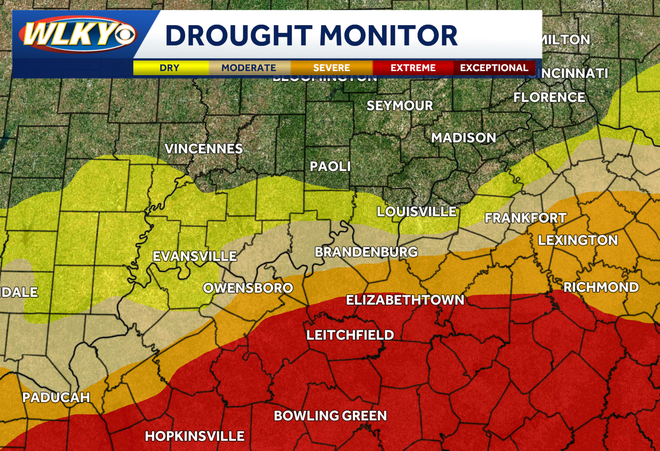
Drought monitor
Counties along and south of the parkways are under a severe drought. This week's rain should continue to help alleviate those conditions.